Find Your Perfect Campground
Browse 67,804+ campgrounds and resorts across the country.
1,773 campgrounds found

1000 Springs Resort
Private campground near Hagerman, ID.
 Map view
1013-006A
Public campground in ID managed by the U.S. Forest Service.
 Map view
1013-006B
Public campground in ID managed by the U.S. Forest Service.
 Map view
1013-011A
Public campground in ID managed by the U.S. Forest Service.
 Map view
1013-011B
Public campground in ID managed by the U.S. Forest Service.
 Map view
1013-013A
Public campground in ID managed by the U.S. Forest Service.
 Map view
1013-013B
Public campground in ID managed by the U.S. Forest Service.
 Map view
208 RV Park
Private campground near Culdesac, ID.
 Map view
289 Old Highway 95
Private campground near Sagle, ID.
 Map view
7N Campground
Campground near Ririe, ID.

7N Ranch Resort
7N Ranch Resort in Ririe, Idaho, offers cabins, RV sites, camping, and the Farmhouse Table Restaurant near Heise Hot Springs and Kelly Canyon Ski Resort
 Map view
8 Mile Camp McCroskey State Park
Campground in ID managed by the Idaho Department of Parks and Recreation.
 Map view
Abbot Campground
Campground in ID managed by the Fairfield Ranger District. Amenities include restrooms. Sites are first-come, first-served.
 Map view
Abbott Campground
Abbott Campground is a primitive non-reservation campground composed of 7 units located on the South Fork of the Boise River. Campground amenities include picnic tables, fire rings and restrooms. Tubing, and fishing are popular activities. There is a footbridge located on the west end of the camp area that crosses the river and accesses the Abbot Gulch area.

Abundant Life RV Park
The newest RV park in Idaho is located in Caldwell Idaho. Providing full hookup RV camping with pull thru and backin sites for daily and monthly stays.
 Map view
Accross From Schwartz Campsite
Campground near Idaho, ID.
 Map view
Across From China Campsite
Campground near Nez Perce, ID.
 Map view
Across From China II Campsite
Campground near Nez Perce, ID.
 Map view
Across From Deer Creek Campsite
Campground near Nez Perce, ID.
 Map view
Across From Miller Campsite
Campground near Idaho, ID.
 Map view
Across Round Springs Campsite
Campground near Idaho, ID.
Adams Ranger Station
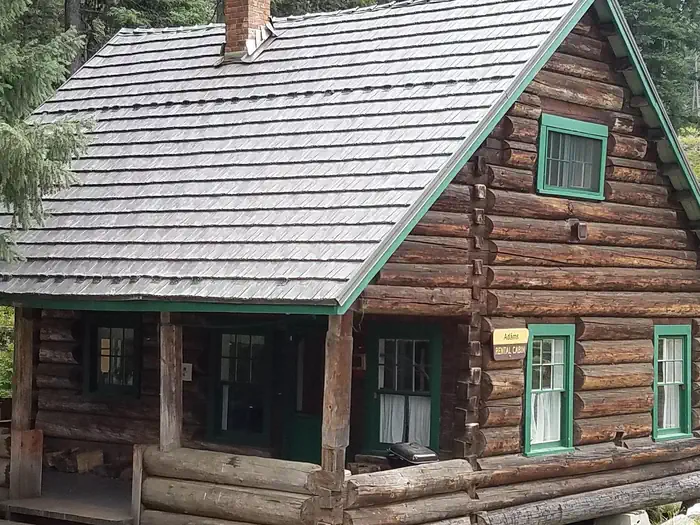
Overview Adams Ranger Station Cabin is located in the heart of the Nez Perce National Forest at an elevation of 5,150 feet. Adams Camp served as a way station along the Milner Trail as early as 1862. The Forest Service established the area adjacent to Adams Camp as an administrative site in 1919. Adams Ranger Station was built in 1932 for the District Ranger and his family. It last served as District headquarters in 1958. Since then, it has served as a work center, hosting a variety of summer crews. The historic cabin is available for rent year-round, except during spring melt, which typically occurs from mid-March to late May. Winter access is approximately 30 miles from Fish Creek Snow Park along a groomed snowmobile route. The cabin must be reserved in advanced; there are no walk-ups. Recreation Many fun activities surround Adams Ranger Station, including numerous trails. Corral Creek, a nearby stock facility and trailhead, can accommodate horses and hikers. This trail system leads into the beautiful Gospel-Hump Wilderness. The Milner Trail, Road #641, is open to off-road vehicles in the summer and snowmobiles in the winter. Facilities The cabin can accommodate up to eight people and has one futon, one double bed, two single beds and two cots. Bedding and blankets are not provided. There is a vault toilet, a propane cook stove (the oven part of the stove is not hooked up to the propane and does not work), dishes, silverware, cookware, bakeware, a table and chairs. Other amenities include propane lanterns, a broom, bucket, mop, snow shovels, axes, mauls and firewood rounds. Firewood rounds provided are for heating the cabin, not for campfires in the fire ring outside. You must provide your own firewood for the outside fire ring. Water is not available on-site. Guests must bring their own or melt snow in the winter. It is recommended that visitors bring flashlights, extra batteries, matches, lighters, garbage bags, candles, lantern mantles, newspapers for lighting fires, warm clothes, rain gear, boots, white gas and small propane canisters, first aid kit, cabin shoes or slippers, maps of Nez Perce National Forest and the Gospel Hump Wilderness and lock combinations. Sleeping bags (0 to 20 degrees) may also be needed. Click here for more cabin details. Natural Features Adams Ranger Station is near the Gospel-Hump Wilderness and part of the Salmon River/Highway 95 Corridor. The landscape in this corridor varies from the emerald Salmon River pouring through steep canyon walls to sapphire Moore's Lake in the remote Gospel-Hump Wilderness. The Gospel-Hump Wilderness has elevations ranging from 1,970 feet at the Wind River pack bridge on the Salmon River to 8,940 feet at the summit of Buffalo Hump. The northern part of the Wilderness is wetter and heavily forested; the southern part is dry and sparsely vegetated. The two parts are separated by a rugged, glaciated divide which contains the peaks for which the wilderness is named. Wildlife in the area includes mountain lions, moose, bighorn sheep, mountain goats and wolves. Nearby Attractions Guests may wish to visit the historic gold-mining town of Florence. It is now a ghost town with a cemetery and a few long abandoned buildings.

Agency Creek Campground
Agency Creek Campground (4 campsites) is located along the Lewis and Clark National Backcountry Byway, near the Lewis and Clark National Historic Trail and the Continental Divide National Scenic Trail. At the top of the pass, there is a memorial to Sacajawea. This secluded, arid area offers a variety of recreation activities including camping, biking, hiking, hunting, OHV riding, picnicking and wildlife viewing. Please be respectful of cultural and historical items found here.
Al Taylor Cabin
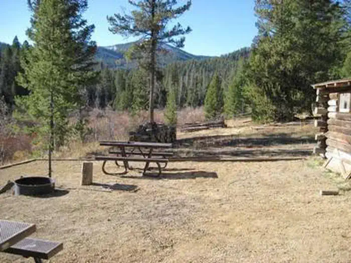
Overview Al Taylor Cabin is located adjacent to Steel Creek near the Continental Divide, at an elevation of 6,300 feet. Visitors come to this area for its beautiful scenery and solitude. Guests can drive to the cabin from mid-May through mid-November with the majority of the trip on gravel roads. These roads are only accessible by snowmobile the remainder of the year. The cabin provides several conveniences, but guests should be prepared to bring some of their own supplies and gear for a comfortable stay. Recreation An off-highway vehicle trail system can be accessed from the cabin. Small streams in the area provide fishing opportunities for brook trout. Other popular activities in the area include hiking, horseback riding and sightseeing. Facilities The cabin can accommodate six people. The cabin has a wood cook stove and wood fireplace as well as propane lights. It provides a small dining table with four chairs. The beds are wooden bunk beds. Other amenities include a fire ring, charcoal grill, picnic tables and a vault toilet - all provided adjacent to the cabin. There is no electricity at the cabin. Water is available at the Steel Creek Campground, located just before the gate to the cabin. Natural Features The cabin is surrounded by large douglas fir trees. It is near both Camas Meadows and the Continental Divide, providing incredible views. Nearby Attractions There are many miles of off-highway vehicle, horseback and hiking trails in the area. The Camas Meadows Battlefield located on the Nez Perce National Historic Trail is located nearby.